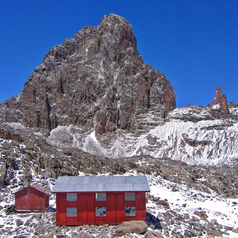

The western approach to Mount Kenya
Naro Moru is direct, historic and full of contrast.
Naro Moru approaches Mount Kenya from the west, entering through one of the mountain’s three official gates and climbing from forest through bamboo and open moorland towards Teleki Valley. It is known for a relatively direct altitude profile, but the route is much more than a shortcut. The change from wet lower vegetation to the Vertical Bog, then into the broad southern valley beneath the peaks, gives it a character found nowhere else on the mountain.
Met Station is the recognised lower mountain base. Above it the trail crosses heath and tussock country before meeting the notorious name of the Vertical Bog. Its reputation comes from wet ground, steep sections and the way rain can transform the path. With good footwear, poles and steady pacing, it is simply one of the route’s distinctive environments rather than a reason to avoid the west.
Higher up, Teleki Valley opens beneath the central peaks. Mackinder’s Camp provides access towards Austrian Hut and the southern approach to Point Lenana. The mountain feels close here: moraine, rock, remnant ice and the great faces above the valley. Naro Moru can be used as an ascent, a descent or one side of an east–west traverse.
Because the route gains height efficiently, programme design matters. A direct line does not remove the need for acclimatisation. We look at where the guest sleeps, whether an extra day can add physiological value, and how Naro Moru connects to the rest of the mountain.
Naro Moru at a glance
A purposeful route with its own landscape.
- Approach
- Western Mount Kenya through Naro Moru Gate
- Lower base
- Met Station area in the forest / bamboo transition
- Signature terrain
- The Vertical Bog and upper moorland
- High valley
- Teleki Valley and Mackinder’s
- Summit link
- Austrian side and the southern Point Lenana approach
- Character
- Direct, varied and often wetter on the lower mountain
- Typical use
- Ascent, descent or western side of a traverse
- Planning priority
- Do not let efficient access compress acclimatisation
The route in four stages
From sheltered forest to the exposed southern basin.
Gate and forest
Montane forest and bamboo make the lower approach feel enclosed. Wildlife may be present but sightings are never guaranteed.
Met Station
The established area marks the transition into heath and moorland and provides a natural first mountain base.
Vertical Bog
Tussock, mud and steeper wet ground create a physical and visual break from the lower route.
Teleki Valley
The route enters open glacial country below the central peaks, with links towards Mackinder’s and Austrian Hut.
The Vertical Bog
Terrain to understand, not a label to fear.
The Vertical Bog is the best-known section of Naro Moru. In dry conditions it can be a rough moorland trail; after rain it becomes saturated and muddy, with wooden sections and eroded alternatives requiring care. Waterproof boots, gaiters and trekking poles can make the day more comfortable.
The right response is patient movement. Rushing encourages slips and widens the trail. Guides choose the most durable line, keep the group together and protect the fragile vegetation by avoiding unnecessary shortcuts.
Above the bog the ground becomes drier and more alpine. The route’s reputation should not eclipse the wider journey: the wet section is one chapter between bamboo and Teleki Valley.
Direct is not automatically better
A short geographic line can create large altitude gains. Strong fitness helps with the gradient but does not accelerate acclimatisation. We use the wider itinerary—rather than the route name—to decide whether Naro Moru is suitable for ascent.
Teleki Valley
The western route opens beneath the main peaks.
Teleki Valley is a broad glacial basin on the south-western side of the central massif. Mackinder’s has long served as a high camp and staging point, while Austrian Hut sits higher towards the southern approaches and technical terrain.
The valley links trekking and mountaineering histories. Point Lenana can be approached from the Austrian side; Nelion’s south-eastern face lies in the wider southern high mountain; and the Summit Circuit can connect this valley to the northern and eastern sides.
Cloud often builds over the wetter western slopes, then parts to reveal the rock towers. The shift from bog to moraine and high volcanic walls is one of Naro Moru’s strongest visual rewards.

Practical Naro Moru
How the western line works.
Access
Naro Moru Gate is an official KWS entrance approached from Naro Moru town. Road and park instructions are checked before departure.
Water
The team uses appropriate mountain sources, then boils or treats water. Guests carry reusable capacity for the walking day.
Camps
Met Station and Mackinder’s are established locations. The exact hut or tent arrangement is confirmed for the programme and current availability.
Weather
The western side can be wet and cloud-prone. Waterproofs stay accessible even in a generally dry season.
Who it suits
Fit trekkers, travellers interested in Teleki Valley, and groups using the route within a thoughtful traverse or acclimatisation plan.
Ascent or descent
It can serve both. As a descent it loses altitude efficiently; as an ascent it needs enough time before the high camp.
Connected journeys
Naro Moru can turn a summit into a crossing.
Naro Moru → Chogoria
A west-to-east journey linking Teleki Valley, the southern high mountain and Chogoria’s lakes and gorges.
Sirimon → Naro Moru
A north-to-west traverse with progressive Sirimon ascent and a direct exit through Teleki Valley.
Naro Moru + Summit Circuit
For well-acclimatised experienced trekkers who want the high geography around the peaks.
Technical south side
Naro Moru provides access towards Austrian Hut and objectives associated with the southern climbing season.
Naro Moru questions
Useful answers before choosing the route.
Is Naro Moru only a descent route?
No. It is a legitimate ascent, descent and traverse route. Its direct altitude profile means the complete programme must protect acclimatisation.
How difficult is the Vertical Bog?
Difficulty changes with rain. Expect wet, muddy and uneven ground; appropriate boots, gaiters and poles help. It is non-technical trekking terrain.
Does Naro Moru reach Point Lenana?
Yes. It connects through Teleki Valley and the Austrian side to the southern trekking approach.
Is Naro Moru less scenic than Chogoria?
It is different rather than inferior: forest, bamboo, bog and Teleki Valley create a concentrated west-side journey.
Can beginners use Naro Moru?
Fit first-time high-altitude trekkers can use it within a well-paced plan. We assess days, sleeping heights and recent walking before recommending it.
Plan a western Mount Kenya journey
Use Naro Moru for more than speed.
Tell us your dates, recent trekking and whether Teleki Valley, Point Lenana, a traverse or a southern technical objective is the priority.