Wilderness Alternative Expedition guide to Tsavo East
Tsavo East does not reveal itself in a rush. The road runs red through thorn and open sky; elephant tracks cross a dry watercourse; a kori bustard steps away into heat. Then the Galana River appears, green and muscular, drawing wildlife to its bends and breaking the apparent emptiness. In Kenya’s largest national park, the spaces between sightings are not wasted time. They are the landscape.
Established in 1948 and covering about 13,747 square kilometres, Tsavo East is larger than some countries. Most safaris use the accessible southern sector around Voi, Aruba and the Galana, while vast northern areas remain remote or subject to different access and security arrangements. A responsible itinerary says which Tsavo East it can genuinely reach.
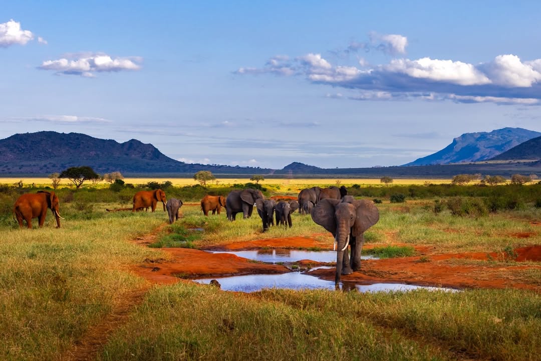
The red elephants of Tsavo
Elephant are Tsavo East’s defining presence. Their red colour comes from dust and mud rich in iron, rubbed and thrown over ordinary grey skin. After bathing they may look dark; after travelling through dry soil they glow brick red. They are not a separate species or subspecies.
Watch a family and the colour becomes the least interesting fact. A matriarch tests the road before calves cross. Adolescents practise threats. Trunks smell, touch and lift dust; ears regulate heat and communicate mood. Tsavo elephant often travel long distances between water and forage, so vehicle position must leave their route open. Kenny teaches guests to recognise the decision before it becomes an encounter.
The Galana River
The Athi River becomes the Galana through Tsavo, creating a permanent ecological artery across dry country. Riverine woodland, doum palms, sandbanks, pools and rocky channels support elephant, buffalo, hippo, crocodile, waterbuck, primates and extraordinary birdlife. Predators use the same movement corridor.
Driving beside the Galana is not a continuous parade. Vegetation hides animals and flood conditions alter the banks. The guide reads fresh crossings, distant dust, alarm calls and the direction of water. A quiet bend at first light may be more productive than a famous landmark at midday.
Lugard Falls and the power of water
At Lugard Falls the Galana is forced through sculpted rock channels and rapids. The name comes from a colonial figure, but the geological story is older: water has cut, polished and rearranged the stone into a narrow, violent passage. Downstream pools can hold large crocodiles.
Visitors use only authorised viewing and parking areas. Rock can be slippery, water level changes and a calm-looking edge can be dangerous. We do not climb barriers, approach crocodiles or turn the stop into a picnic outside designated rules. In high flow, the sound and power carry farther than any photograph.
Yatta Plateau: lava on the horizon
The Yatta Plateau runs along the park’s western side and is widely described by KWS as the world’s longest lava flow. It was formed by ancient lava associated with the eastern Rift highlands, then shaped by erosion until it became a long, elevated line above the plains.
It is often a background rather than a place reached on an ordinary southern circuit. This matters when choosing photographs and itinerary language: a guest may see the Yatta without driving its full length. In clear light it gives Tsavo East scale and a geological boundary that wildlife crosses without regard for tourism maps.
Mudanda Rock
Mudanda is a long, whale-backed rock above a natural catchment where elephant and other wildlife may gather in dry conditions. From the top, the eye can travel across bush and water, making it one of the park’s strongest landscape stops.
Wildlife presence depends on water and season. The rock is exposed and hot; footwear, water and supervision matter. Guests leave vehicles only where KWS permits and first check the immediate area with their guide. A viewpoint inside a national park is still wildlife habitat.
Aruba Dam and the southern circuit
Aruba Dam creates a dependable focus for wildlife when surrounding country dries. Zebra, buffalo, elephant, waterbuck, giraffe and predators may use the area, while open ground gives strong visibility. It can also attract vehicles, so we judge whether to wait, change angle or leave for a quieter water source.
Voi and Bachuma approaches make the south practical from Mombasa; Manyani and Mtito Andei connect the Nairobi highway; Sala Gate opens a route towards Malindi. “Near the coast” does not mean short once park roads, gate formalities and lodge location are included.
Lions, plains game and northern character
Tsavo lions are sometimes described as maneless. Adult males may have sparse or shorter manes, influenced by genetics, climate, age and condition, but the park does not contain a separate lion species. The famous 1898 railway attacks belong to Tsavo history and should not turn every modern lion into a descendant myth.
Leopard, cheetah, spotted hyena and African wild dog occur but are never guaranteed in such a large system. Giraffe, zebra, buffalo, Coke’s hartebeest, Grant’s gazelle, gerenuk, lesser kudu and fringe-eared oryx give East a dry-country community different from the Mara. The critically endangered hirola is associated with parts of the wider eastern landscape; an ordinary southern Tsavo safari must not promise it.
Birding on a continental route
More than five hundred bird species have been recorded. Resident dry-country birds overlap with waterbirds along the Galana and migrants moving between continents. Vultures, eagles, hornbills, rollers, bee-eaters, coursers, sandgrouse, bustards and starlings can turn a slow morning into a full field session.
Rain changes birding quickly. Temporary pans fill, insects emerge and migrants spread beyond permanent water. We use binoculars and sound carefully, without excessive playback near nests or territorial birds.
How to photograph Tsavo East with Kenny
The red palette can fool a camera’s meter and white balance. Kenny helps guests keep elephant skin textured, avoid oversaturating the soil and expose pale sky without losing the animal. Dust is most powerful when side- or backlit; a fast shutter freezes it, while a slower one can show movement.
Heat shimmer limits long-lens detail by midday. The answer is often to wait for closer natural movement or make an environmental frame, not to leave the road. From Mudanda, a wide lens can hold water, animals and horizon. Beside the Galana, branches and palms become foreground rather than obstruction.
How long to stay
Two nights give a useful southern introduction if the camp and gate match the route. Three nights are better: they allow a Galana day, the Aruba–Mudanda country and time for animal movement rather than transfer pressure. Four nights suit photographers, birders or guests using a more remote camp.
East and West require at least four nights combined, ideally more. Crossing the highway and completing gate formalities take time even though the parks touch on a map.
Getting there
Road access includes Voi, Bachuma, Manyani, Mtito Andei and Sala, each serving a different approach. Nairobi and Mombasa distances quoted to a gate do not include the internal drive to camp. We calculate the whole day.
Passenger SGR services can stop at Voi or other confirmed stations, followed by a private safari vehicle. Airstrips include Voi and Ithumba plus several smaller fields; scheduled use changes, so flights and baggage limits are verified before sale.
Where to stay
Camps near the Galana offer river atmosphere and northern access; Aruba-area properties focus on water and open game country; Voi-side lodges work well for road and rail arrivals. Waterhole lodges can deliver wildlife at rest, especially during dry periods.
We choose exact location before room category. A camp marketed as Tsavo East may be outside a gate or in a neighbouring conservancy, changing entry fees and daily routes. That can be an advantage if explained honestly.
Best time to visit
Drier months generally concentrate wildlife around the Galana, Aruba and other reliable water, while vegetation is lower and red dust strongest. Rain brings green growth, young animals, migrants and dramatic storms. It also disperses wildlife and can make secondary tracks difficult.
Tsavo is warm, with very hot middle hours in some seasons. Dawn and late afternoon drives protect both photography and comfort. There is no month that guarantees elephant at one named waterhole.
Combining Tsavo East
East connects naturally to Tsavo West for a complete ecosystem journey and to Kenya’s coast through Voi, Bachuma or Sala. It can also follow Amboseli, though West normally creates the more logical protected-area bridge. Every coast transfer is matched to the actual beach property rather than a generic “Mombasa” label.
Responsible travel in Tsavo East
- Never block elephant access to water or a family crossing.
- Stay on authorised roads and respect every northern-sector or security restriction.
- Approach Lugard Falls and Mudanda only through designated visitor areas.
- Keep food secure and all waste inside the vehicle until proper disposal.
- Do not promise or broadcast sensitive species locations.
- Use the park’s scale to slow down, not as a reason to speed.
Tsavo East FAQ
Are the elephants naturally red?
Their skin is grey. Red dust and mud coat it, creating Tsavo’s famous colour.
Can we see the whole park?
No. It is enormous, and ordinary tourism concentrates in selected sectors. We design a coherent region rather than claiming complete coverage.
Is Tsavo East good for first-time safari guests?
Yes, when they value landscape and understand that sightings may be farther apart than in smaller reserves.
Can we arrive by train?
Yes, using a confirmed SGR service and a private vehicle meeting the correct station. Timetables and station stops must be checked.
How many nights do we need?
Two are workable; three make a far stronger first Tsavo East safari.
Plan a private Tsavo East safari
Tell us your dates, entry point, onward destination and wildlife or photography priorities. We will choose the right gate and camp so the journey spends time beside the Galana and in red-earth country rather than simply crossing the park.
Plan Tsavo East with Wilderness Alternative Expedition
Wildlife sightings, water levels, road and sector access, rail and flight schedules depend on natural conditions, park rules and confirmed operations.